EXPEDITION: DINOSAUR
Iremos-Anabasis, the Peaceful March of the Seven Roads. Nothing about Dinosaurs.
Seven dirt roads make up the core of this route, reminiscent of the seven books of Anabasis but without all the war and family issues. It’s more of an Iremos-Anabasis: Iremos (“tranquil. peaceful” in Greek, and as a nice coincidence, “we go” in Spanish) combined with Anabasis (“expedition up from” in Greek), to make up Peaceful Expedition because of the great amount of solitude and tranquility we found as we went up to the far northwest corner of the state. All seven roads were worth exploring but Yampa Bench road in Dinosaur National Monument is by far the standout. There are many historic and interesting stops along the way, including the Rial Chew ranch, a mud and stick hut, cabins, petroglyphs, incredible overlooks and the Whispering Cave. The environment is much like Utah, with stunning desert landscapes in all directions that change frequently. The five notable roads leading up to Yampa Bench were excellent as well, however our exit through the gorgeous West Rifle Creek area south of Meeker was the best surprise of this overland odyssey.
Technical:
Start Point: Fraser
End Point: New Castle
Total Mileage: 468+/-
Difficulty: Easy
Highest Elevation: 10,438
Season Travelled: Late Summer
Permits Required For: n/a
Delorme Atlas & Gazeteer™ Colorado (in order of route):
p. 22-8, 34-8
Camping:
Established campgrounds in the Flat Tops Wilderness:
Bear Lake Campground
Chapman Reservoir Campground
Cold Springs Campground
Horseshoe Campground
Sheriff Reservoir Campground
Vaughan Lake Campground
Yampa Ranger District Office
Dispersed Camping in the Flat Tops Wilderness:
Allen Basin Reservoir & ATV Trail #1181
Bear River Developed Camp Sites
Crosho Lake Recreation Area
Trout Creek Recreation Area
Sleepy Cat / Yellow Jacket Pass
Camping in Dinosaur National Monument:
NPS / DSM Campgrounds Page
Other:
Rifle Gap State Park
Rifle Falls State Park
Route Video: EXPEDITION: DINOSAUR (youtube)
CR55 Cottonwood Pass -we got here via Highway 40. It’s just north of Fraser, south of Granby next to Granby Ranch. This is not the famous Cottonwood Pass down by Buena Vista; much like Spring Creek, Deer Creek, Rock Creek and such Cottonwood Pass is a commonly used name. It’s a wonderful way to start the trip, the road is easy and beautiful with Cottonwoods, Aspens and Pines all along it’s length. The west end terminates at the small town of Hot Sulphur Springs, where we took Highway 40 to CO 134 through Kremmling to get to CR 16.
Video of this road: CR55 Cottonwood Pass
CR16 / Stagecoach Reservoir -I heard about this road and the last one from DS riders. This is part of the Colorado Backcountry Discovery Route and I can see why, it’s perfect for motorcycles. Lovely scenery and long smooth stretches made this an easy and fun drive. Up near the reservoir we turned left on CR 14 and left again on CO 131 down to Phippsburg.
Video of this road: CR16 / Stagecoach Reservoir
CR8 Flat Tops Scenic Byway -This road travels along the Flat Tops Wilderness and is a Colorado Birding Trail as well as a Colorado Scenic Byway. The road surface is well maintained dirt and gravel with a few areas of surprisingly rough washboards. I really can’t describe how beautiful the Flat Tops Wilderness is, and how big it feels. The drive was wonderful for the first 49 miles until the road becomes paved. Just west of the beginning of pavement is a turnoff for FR 245 Buford-New Castle road which is on my list for future exploration. The drive west to Meeker is still lovely, but with the pavement it’s just another rural highway. Great camping near Meeker at Sleepy Cat / Yellow Jacket Pass.
Video of this road: CR8 Flat Tops Scenic Byway
CR155 Trapper’s Lake -this is an in and out detour along the way to a famous lake that has been in countless photographs. Unfortunately a pine beetle infestation driven by drought has killed off much of the forest surrounding Trapper’s Lake and the smaller Lake of the Woods along the road leaving it decimated and it was an unexpectedly sobering experience to view it. There is new growth in much of the affected area, and while it is quite dramatic to see the devastation up close it is a small portion of an incredible wilderness that will recover in time. Overall the drive in and out was excellent and I would do it again.
Video of this road: CR155 Trapper’s Lake
CR23 Sheepdog Drive -From Meeker we took CO 7 to CR23 to Highway 40. A herd of Pronghorns were crossing the road when we arrived and we saw a few more along the way. The road is a flat desert mix of dirt, sand and clay that was hardpacked and easy with excellent desert views along ranch land. There were some significant ruts that were easily avoided, we did not use 4wd. A few miles in we encountered a dog laying next to a gate as we were wondering if this road had a name aside from 23. We joked that it should be called Sheepdog Drive and the dog raised his head and barked once, as if in agreement. He wasn’t agreeing with us at all, he was actually alerting to massive livestock guardian dogs that made a beeline for our vehicle and chased us for about a mile at around 25mph. It was both awesome and scary, I’m very glad we didn’t have to tangle with those behemoths!
Video of this road: CR23 Sheepdog Drive
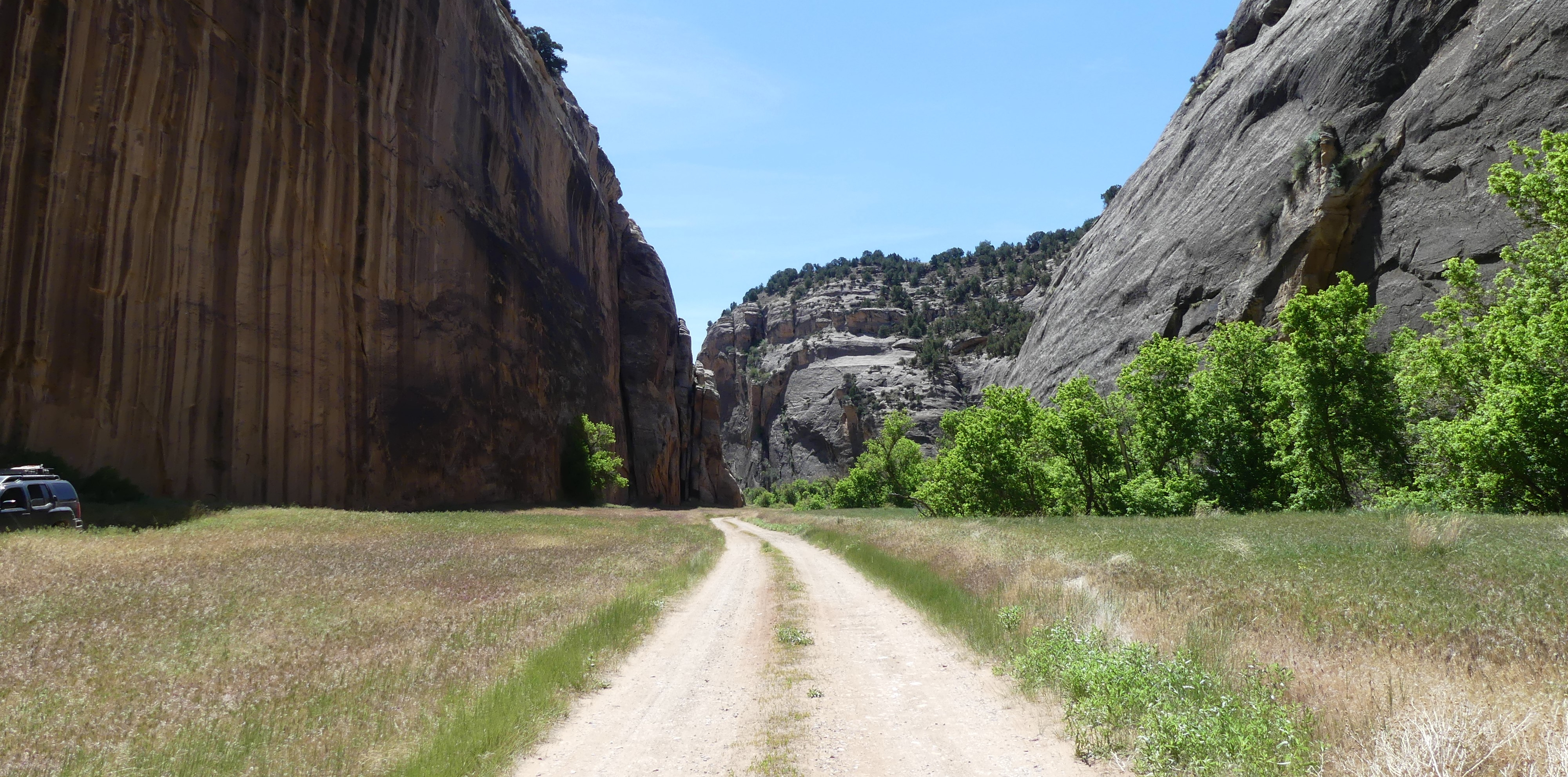
Yampa Bench Road -From the tiny town of Elk Springs along Highway 40 we picked up 14 and 14n to Yampa Bench, Echo Park and Harper’s Corner. The term “epic” is overused in overlanding, it should be reserved for roads like this one. The road has switchbacks at both ends of the Monument that are easy and give incredible views of the entire road. We dropped down into the valley at the east end where a fire has left a ghost forest of bushes and short trees that is unlike anything I’ve seen before or since. Aside from the ghost forest this road is often surrounded by sage, pine, juniper and other desert growth that smells incredible. The road gets more fun to drive as you head west into the huge rock formations and desert hills. There are a few overlooks and some cabin ruins along the way, but the fun really starts at the turnoff for Echo Park. The Rial Chew ranch, a small dirt roofed cabin, Whispering Cave and some Petroglyphs are all along the road to Echo Park. Echo Park was closed when we got there so we did not get to go to the river, but the campground area is lovely and the beauty of the drive is second to none. Read about the park attractions here. The switchbacks up to Harper’s Corner road were easy and we had to stop part way up for pictures, the view back over Yampa Bench road is just awesome. Further along Harper’s Corner we stopped at a few overlooks with Echo Park Overlook being the best one; we could see what we had driven that day and we spent quite some time just standing there. I loved Yampa Bench road, it was one of the best overland roads I’ve ever driven.
Video of this road: Yampa Bench Road
West Rifle Creek -We were surprised by how lovely this road was, I liked it even better than the Flat Tops Scenic Byway. Along the way is access to Hay Flat, lots of Aspen groves, small ranches and wide stretches of forest. The road surface is dirt and gravel with some minor ruts that was easy, probably wouldn’t be if it was wet. We drove by Rifle Gap Dam to Rifle Falls State Park, then down to New Castle where the route ends.
Video of this road: West Rifle Creek
Individual Whole Road Video Links:
If you’d like to support this site please subscribe to our channel on youtube
Copyright © 2024 All Rights Reserved
All materials on this site are protected by copyright and intellectual property laws and are the property of the Author. You may not reproduce this material on your personal website, blog, social network, or any other online, offline, digital or print resource without permission.
You may only access and download the materials located on ColoradoOverlandRoutes.com for personal, non-commercial use.
